| Automated charting and reporting |
SharpPlot Tutorials
General Tutorials
Chart Samples
Style Examples
SharpLeaf Tutorials
Document Layout Tutorials
Text Flow Tutorials
Table Tutorials
Visual Glossaries
SharpPlot Class
SharpPlot Properties
SharpPlot Structures
SharpPlot Enumerations
PageMap Class
SharpLeaf Reference
SharpLeaf Class
SharpLeaf Properties
SharpLeaf Methods
Table Class
Table Properties
Table Methods
SharpLeaf Structures
FontType Structure
ParagraphStyle Structure
BoxStyle Structure
SharpLeaf Enumerations
DocumentLayout Classes
DocumentLayout Class
PageLayout Class
PageElement Abstract Class
Frame : PageElement Class
TextBlock : PageElement Class
ImageBlock : PageElement Class
Box : PageElement Class
Rule : PageElement Class
Common Reference
Document Class
VectorMath Class
DbUtil Class
Download
Release Notes
Licensing
SharpPlot Reference > SharpPlot Methods > SetAltitudeColors Method
SharpPlot.SetAltitudeColors Method
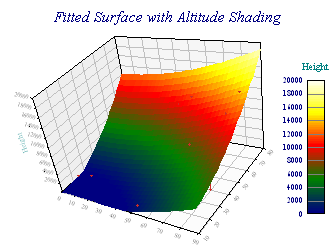
Set an array of colors for use by altitude-shaded plots. If a single color is used, it will be smoothly graded to white. An array of colors will be used as step values, and an equal number of interpolated colors created between each pair.
Example
sp.SetAltitudeColors(Color.DarkKhaki); // Good for a landscape map
sp.SetAltitudeColors(new Color[]{Color.Navy,Color.Green,Color.Red,Color.Yellow});
// Typical false-color set
Overloads
- public void SetAltitudeColors(Color value);
- public void SetAltitudeColors(string value);
- public void SetAltitudeColors(Color[] colors);
Altitude shading is supported by the contour plot, and the cloud chart with a fitted response surface. You can also have altitude-shaded markers as a BubbleChart style.